Active transportation planners talk a lot about connectivity and closing gaps.
For trails, a gap is sometimes a clear missing link along a linear corridor. Two New England examples include the 1.6-mile gap in the Eastern Trail between Scarborough and South Portland, ME, which the Eastern Trail Alliance is working hard to close. Another is the roughly 4-mile gap in the Farmington Canal Heritage Trail in Plainville, CT. That gap is, for the most part, the only missing link in the FCHT corridor for about 60 miles from New Haven to Westfield, MA. The design of a project to fill that gap began in 2018.
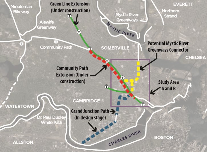
Sometimes, the gap is three-dimensional, such as an area where multiple trails don’t quite converge. Or where multiple future trails, after they are built, will stop short of connecting. This is the case for the eastern parts of Somerville and Cambridge, and a newly released feasibility study (PDF, referred to here as the “CPX Connection Study”) has explored ways of tying everything together.
The study was conducted by Alta Planning + Design for two community trail groups — Friends of the Community Path and Friends of the Mystic to Charles Connector. Additional support came from the Mystic River Watershed Association (MRWA), the Somerville Community Corporation, and the Friends of the Grand Junction Path. The study was funded by the Commonwealth of Massachusetts through the MassTrails program. The number of groups involved suggests just how important this area is for trail connectivity.
The challenge of filling in multiple trail gaps
Here’s how I would describe the challenge in a nutshell:
- Access to existing and planned paths along the Mystic River. The Mystic Greenways Initiative of the MRWA seeks to “connect 25 miles of paths, improve hundreds of acres of parklands and engage thousands of community members from the Mystic Lakes to the Boston Harbor.” Currently, there are intermittent path segments on each side of the river, with many projects in the works to fill in gaps and connect to adjacent trails. A high-profile focus area in recent years has been the Encore Boston Harbor Casino in Everett, where new paths, a harborwalk, and protected bike lanes have been built; where the Mystic River Crossing project will be located; and where a future connection to the regional Northern Strand Community Trail is anticipated. The Assembly Square path links with the Mystic Greenway (sometimes referred to as the Mystic River Greenway or MRG) on the south side of the river, but that path terminates at high-stress Mystic Ave.
- Access to the eastern end of the Somerville Community Path Extension (CPX) being built as part of the MBTA Green Line Extension (GLX). The CPX will terminate at a relocated Lechmere Green Line station and the Cambridge Crossing (CX) mixed-use development. From there, a path extends east through the CX project’s park, past the Hult International Business School, and to North Point Park and Paul Revere Park via the North Bank Bridge. When you think about two adjacent projects — the City of Boston’s in-design Rutherford Ave. project, which will feature a linear park and sidepaths, and MassDOT’s under-construction North Washington Street Bridge Replacement Project, which will provide wide sidewalks and protected bike lanes connecting to the North End and the Connect Historic Boston cycle track — you get excited about the emerging bike network! But that is primarily a radial link toward downtown Boston. The question remains as to how to forge more connections from the CPX to other parts of Somerville and Cambridge to the south. That’s partly where the next project comes in.
- Connecting the CPX with the in-design Grand Junction Path (GJP). As the CPX Connection Study notes, “Once completed, the CPX (under construction) and GJP (in design) will come close, but not connect, to each other.” As noted on the City of Cambridge website, the GJP is “a proposed multi-use path to be built next to the railroad tracks in the Grand Junction corridor from the Boston University Bridge to Somerville.” Planning for a shared use path in this MassDOT/MIT-owned, active-but-infrequently-used railroad corridor has been ongoing for 20 years, and the GJP is now in the detailed design phase. The connectivity benefits of the GJP cannot be understated: not only are nearly half of all Cambridge jobs and nearly one-third of all residents within a half-mile of this project (see link above for these stats), but the southwest-to-northeast orientation of the project provides low-stress bicycling connectivity in a direction other than the primarily northwest-to-southeast orientation of Cambridge’s radial streets. In other words, projects like the GJP will help cyclists “cut across” the Cambridge grid. Yes, some existing and planned facilities also aid this non-primary movement (e.g. the adjacent Vassar St. SBL, Ames St. SBL and the Kittie Knox Bike Path, Western Ave. SBL, and the planned River St. SBL), but the GJP would be a “grand” addition to this axial group. And, to top it all off, there is hope that one day, the GJP will connect with the Charles River pathway system via a new crossing of the river — another idea that has been weighed in planning processes going back at least to the 1990s, which I won’t cover in this post.
Connectivity benefits
The CPX Connection Study recognizes the importance of connecting all of these projects, keeping an eye on the regional picture:
The Study Area described above has the potential to form the nexus of multiple shared use paths. If links between the CPX, the GJP and the MRG can be established, it would provide critical connections between dozens of miles of shared use paths throughout the region.
If the CPX and GJP can be linked by an off-road path connection, commuters and recreational users traveling via Somerville and East Cambridge would have seamless access to job hubs such as Kendall Square and Lechmere, as well as the entire Charles River Basin trail system. Furthermore, if the MRG were linked to the CPX, a commuter living adjacent to any of the burgeoning area path systems could bicycle to numerous employment centers without ever riding adjacent to heavy automobile traffic. Lastly, this Mystic-CommPath link would allow travelers on the 104-mile Mass Central Rail Trail to continue northeast on the Border to Boston trail, a segment of the East Coast Greenway. [URL text replaced with hyperlinks for this quote]
The CPX’s regional trail connectivity benefits were also described in a 2013 report (PDF) from the Metropolitan Area Planning Council (MAPC):
The Community Path Extension is one of the most important bicycle and pedestrian infrastructure projects in the Metro Boston region. Once completed, it will close a two-mile gap bridging a network of paths extending 48 miles connecting communities from Bedford to Boston to Newton and Waltham.
Those paths include the Minuteman Bikeway and Narrow Gauge Rail Trail (extending, in tandem, from Cambridge to Billerica), the Paul Dudley White Path on each side of the Charles River, and the Alewife Brook Pathways. In short, Cambridge and Somerville — already two of the most walkable and bike–friendly communities in the U.S. — are emerging as regional trail hubs.
Really, there are two trail convergence areas — one by the Alewife T station, where the Minuteman, Fitchburg Cutoff Path (extending west as part of the Mass Central Rail Trail), Fresh Pond path, Alewife Linear Path, and existing Somerville Community Path all come together. The other is the area addressed by the CPX Connection Study, and the link between them is the Somerville Community Path and CPX.
With all of this connectivity and the fact that the existing Community Path is so heavily used, it’s not surprising that we see projections of robust demand, post-CPX-completion. The MAPC Study estimated that with the CPX built the extended Community Path could see as much as 3 million annual trips. (Projecting 2011 peak-hour counts to an annual total, MAPC estimated that the existing Community Path saw 3,650 users on an average day and 730,000 annually.) And the CPX Connection Study pointed to the 2011 GLX environmental assessment’s projection of “6,975 daily walk trips and 440 daily bike trips to the new Lechmere station” — not to mention other stations and other trip purposes.
In summary, what does the CPX Connection Study recommend?
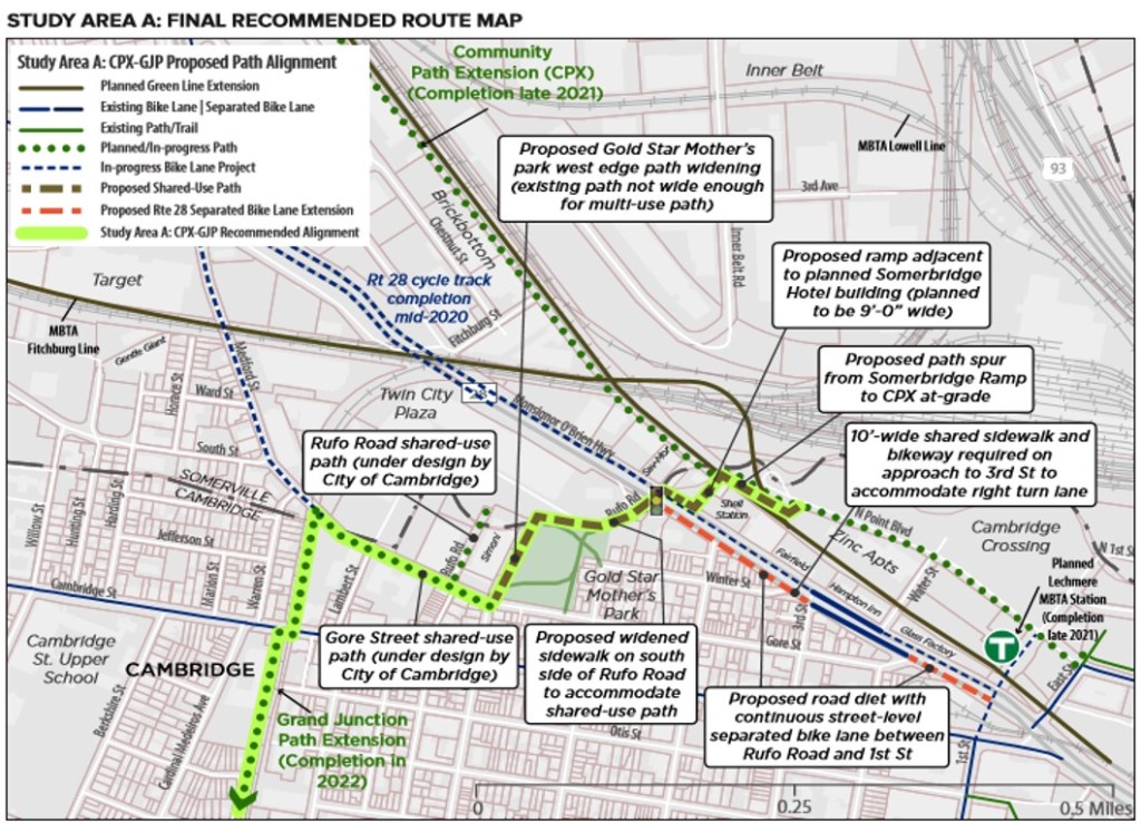
For connecting the future GJP and CPX, the study recommends:
- A shared use path on Gore St. (already in-design by the City of Cambridge)
- Widening the path on the western edge of Gold Star Mothers’ Park (rather than adapting the narrow path through the middle of the park, as the 2015 Closing the Gap study recommended) – estimated cost: $170,000, not including recommended snow guards for falling snow from Simoni Skating Rink
- Working with Twin City Plaza shopping center and MassDCR to extending the path from the park to Rufo Rd. via the repurposing of 4-5 parking spaces – estimated cost: $270,000
- A new crosswalk at the intersection of Rufo Rd. and McGrath Hwy. (state-maintained), including upgraded curb ramps, new pedestrian signal heads, a leading pedestrian interval (LPI), and a no-right-turn-on-red restriction – estimated cost: $97,000
- A McGrath Hwy. sidepath and ramp to be built by the planned (and permitted [PDF]) Somerbridge Hotel site at 1 McGrath Hwy., a development site which straddles both jurisdictions
- A spur connecting from the Somerbridge Hotel ramp to the CPX just south of the MBTA maintenance facility – estimated cost: $110,000 (another potential connection route could be implemented over the long term only if the SavMor Liquors site at 15 McGrath Hwy. is redeveloped)
- Just to add one thought of my own to the mix: Given the need for this connection to zig-zag and meander, wayfinding signage will be especially important.
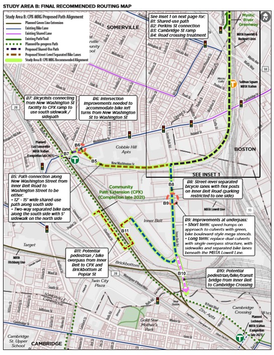
For connecting the MRG and future CPX, the study recommends:
- A path along MBTA tracks from the current MRG terminus at Mystic Ave. looping south, then west, to Inner Belt Rd. and New Washington St. The path would replace an infrequently-used freight storage track, and would include an additional fence to separate the path from the other tracks – estimated cost: $1.48 million
- A sidepath or separated bike lanes along New Washington St., with crossing improvements at Inner Belt Rd. and New Washington St. – estimated cost of SBL-sidewalk option plus intersection improvements: $1,270,000
- Separated bike lanes along Inner Belt Rd. from New Washington St. to the end of the road (with short-term recommended traffic calming at the pinchpoint that is the culvert overpass of the MBTA Lowell Line — and overpass reconstruction in the long term) – estimated cost for SBLs and short-term traffic calming at culvert overpass: $127,000
- A potential long-term bike-ped overpass from the end of Inner Belt Rd. over the GLX to connect with the CPX and Brickbottom at Chestnut and Poplar Sts.
- A potential long-term bike-ped-transit-only bridge from the southern apex of Inner Belt Rd. to the Cambridge Crossing (CX) development.
Those are just some highlights. The study also includes a route analysis, summary of public input, next steps, potential funding sources, design guidelines, and a benefit analysis.
Overall, connecting these three paths/path systems will be a huge benefit to not only Cambridge and Somerville, but to trail users in the greater Boston region and East Coast Greenway travelers as well. The study is a solid stepping stone toward those benefits. Once again, here is the PDF link to the study.

One thought on “Closing gaps in Cambridge and Somerville”